Shopping for a Lake Travis waterfront lot should feel exciting, not uncertain. You want a property that lives beautifully now and protects your investment when it is time to sell. The good news is that long-term value on Lake Travis follows clear rules once you know what to check. In this guide, you’ll learn the critical factors that separate great lots from risky ones and how to verify each item before you commit. Let’s dive in.
What drives long-term value
You can simplify your short list by focusing on a few high-impact items:
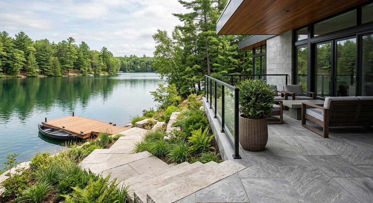
- Dock rights and water depth. Confirm that a residential dock is permitted or likely to be permitted at your shoreline, that authorization can transfer, and that typical water depths support your boat. Start with the LCRA guidance for docks and marinas.
- Buildable area above flood levels. Make sure the usable building pad sits above mapped flood zones and respects shoreline setbacks. Review Travis County rules and FEMA maps for a quick screen.
- Reliable utilities. Sewer versus septic, potable water, power, and broadband affect livability, cost, and resale.
- Lake-level variability. Lake Travis is actively managed. Design choices should plan for both drawdown and flood operations. The LCRA key elevations are your baseline.
- Local shoreline rules. County setbacks and the LCRA Shoreline Management Program shape what you can build and where.
Understand Lake Travis rules
LCRA’s role and why it matters
The Lower Colorado River Authority (LCRA) manages lake operations and sets safety standards for docks and marinas. On Lake Travis, a residential dock may extend up to 100 feet from shore if conditions allow, and placements must respect cove-width and safety rules. Always confirm whether an existing dock has a valid authorization and whether it transfers with the lot using the LCRA docks and marinas page.
Shoreline work, dredge, and stabilization
Any dredge or shoreline stabilization typically requires LCRA notification or permits, and larger projects can trigger state or federal review. Before budgeting for riprap, seawalls, or channel clearing, read the LCRA dredge and fill process.
Septic oversight around the lake
If a lot will rely on on-site sewage, expect LCRA involvement within its jurisdictional buffer. Design, permitting, and maintenance records sit with the OSSF program. Start your records check here: LCRA OSSF.
County setbacks and floodplain checks
Travis County development rules set shoreline setbacks that shape your final building pad. For Lake Travis, the shoreline setback is typically 100 feet inland, with some detached single-family lots at 75 feet, as outlined in Chapter 82. Review the county text here: Travis County Development Regulations. Then verify flood zones on the FEMA Flood Map Service Center and confirm finished-floor elevation requirements with county staff.
When federal and state agencies are involved
Major dredge or fill work may require a U.S. Army Corps of Engineers authorization in addition to LCRA and county approvals. The starting point is the USACE permitting overview. Some aquatic vegetation treatments also need coordination through LCRA and state programs.
Lot features that matter most
Orientation, views, and privacy
A lot’s angle to the water drives where you will place living areas, terraces, and glazing. Study the survey and topography to map view corridors and consider whether recorded view or building easements protect your outlook. Plan your window and shading strategy to balance comfort and maintenance.
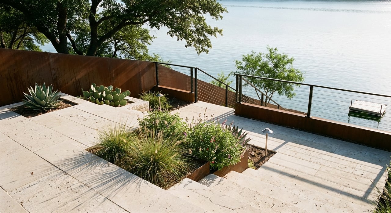
Slope, topography, and the buildable footprint
Steeper sites can be stunning, but they change foundation choices and driveway design. Travis County rules limit heavy cut and fill and may require engineering reviews on sensitive or steep lots. Before you budget, review Chapter 82’s grading provisions in the county regulations and schedule a geotechnical evaluation.
Shoreline type and your dock strategy
Rock ledge, sloped turf, shallow coves, or vertical banks each carry different dock and stabilization paths. The LCRA may refuse docks in hazardous or very shallow areas, and on Lake Travis the dock can typically extend up to 100 feet from shore if conditions allow. Verify water depths at average and low lake stages and confirm whether dredging would be needed, then validate your plan with the LCRA dock rules. Floating docks with adjustable gangways usually perform better through seasonal swings.
Flood risk and lake operations
Design starts with key lake elevations. Lake Travis is managed to a full conservation level near 681 feet msl, and the spillway elevation is about 714 feet msl. Flood operations change as the lake rises, which affects dock safety, access, and potential flood insurance needs. Study the LCRA key elevations and confirm your parcel’s FEMA map panel on the FEMA MSC before you settle on a building pad.
Soils, erosion, and shoreline protection
Look for signs of undercutting, slumping, or recent repairs. Stabilization can be bioengineered or hard-armored and almost always requires permits. If you inherit prior shoreline work, make sure it is documented and permitted. Clean records are a value add at resale.
Utilities, access, and community
Water and wastewater
Sewer access can be a major swing factor for design and cost. Parts of the south lake area are served by Travis County WCID No. 17, which provides potable water and wastewater to many neighborhoods. Start utility confirmation with the provider at WCID 17 and pair that with a records request through LCRA OSSF if a septic system is involved.
Electricity and broadband
Power providers vary by location. In and around Lakeway, service is often from PEC or Austin Energy, and utility upgrades can affect timelines. Use the City of Lakeway’s resource page to orient yourself to providers: Lakeway utilities overview. For remote work or smart-home systems, verify fiber or cable availability by address during your option period.
Road access and emergency services
A steep private drive can raise construction and maintenance costs. Confirm who maintains the road, driveway grade, and year-round emergency access. Insurance carriers may ask about fire district coverage and hydrant availability, especially if a private well is planned.
HOAs, marinas, and community rules
Covenants often set dock design standards, marina rules, rental policies, and guest access. If the neighborhood has a community marina, ask about fees, slip assignments, and reserve funding for repairs. LCRA updated its marina ordinance in 2023 after a period of tighter controls, which can affect future community slips; review this context in local reporting on the new ordinance.
Due diligence checklist
Use this short list to structure your offer and option period:
Core documents
- Current ALTA or long-form survey showing shoreline, easements, flood boundaries, and any recorded dock or marina authorization.
- Title commitment with all exceptions and any recorded LCRA easements or reservations. Cross-check with LCRA dock records.
- Any existing LCRA authorizations for docks, buoys, shoreline work, plus OSSF permits and maintenance records through LCRA OSSF.
- FEMA FIRM panel and any elevation certificates from the FEMA MSC.
Inspections and feasibility
- Licensed site evaluator’s percolation test and OSSF suitability if no sewer is available.
- Geotechnical report for slope stability, foundation recommendations, and retaining wall design.
- Marine survey with water-depth soundings at typical low and average levels; confirm feasibility with LCRA dock standards.
- If shoreline work is planned, consult the LCRA dredge and fill process and, for substantial work, the USACE permitting overview.
Specialists to engage
- Land surveyor for ALTA updates and to plot waterway setbacks per Travis County regulations.
- Geotechnical and civil engineers to design foundations, drainage, and driveways that comply with county rules.
- Licensed OSSF designer if septic is required, and a marine contractor with Highland Lakes experience for dock design and permitting.
Smart contingencies
- Satisfactory ALTA survey and title review with no uninsurable LCRA reservations or shoreline easements that limit use.
- Written confirmation of sewer availability and capacity or a satisfactory OSSF evaluation.
- Geotechnical report supporting a feasible, cost-reasonable foundation approach.
- Confirmation of an existing, transferable LCRA dock authorization or written feedback from LCRA indicating new authorization is likely.
How these choices protect resale
- Dockable frontage with deep water is scarce and drives demand. A clean, transferable LCRA authorization is a powerful selling point supported by the LCRA docks and marinas standards.
- A generous, buildable pad above flood elevation reduces complexity, insurance exposure, and buyer objections. Always tie your plan to current FEMA maps.
- Reliable utilities increase year-round appeal and simplify underwriting. Start utility due diligence with WCID 17 where applicable.
- Permitted shoreline work and documented maintenance lower the risk of future remediation and help the next buyer feel confident.
- Clear HOA and marina policies let buyers understand true ownership costs and privileges, including any implications of the 2023 marina ordinance update highlighted in local coverage.
When you focus on these fundamentals, you protect both how the home will live and how the property performs when it is time to sell.
Looking for a seasoned partner to help you evaluate specific lots, coordinate specialists, and surface on and off-market options that fit your vision? Reach out to Jana Birdwell for a private, data-informed consultation tailored to Lake Travis waterfront.
FAQs
How do Lake Travis water levels affect a future dock?
- Lake Travis is managed to about 681 feet msl at full and can rise toward the 714-foot spillway in flood operations, so plan for floating docks and adjustable gangways using the LCRA key elevations as your baseline.
What is the typical Travis County shoreline setback on Lake Travis?
- The county generally requires a 100-foot setback from the shoreline, with some detached single-family situations at 75 feet, as outlined in Travis County’s Chapter 82 regulations.
Do I need a permit to build a residential dock on Lake Travis?
- Yes, docks require LCRA authorization, must meet safety rules, and on Lake Travis can typically extend up to 100 feet if conditions allow, so start with LCRA’s dock standards.
How can I confirm if a lot has sewer service or needs septic?
- Check the local provider, such as WCID 17, and if sewer is unavailable consult the LCRA OSSF program for site evaluation and permit history.
Who approves shoreline stabilization or dredging on Lake Travis?
- LCRA regulates dredge, fill, and stabilization work, and larger projects may also require a USACE permit, along with county approvals.
Are new community marinas being approved around Lake Travis?
- LCRA updated its marina ordinance in 2023 after earlier limits, so community slip prospects depend on current rules and location; review the context in local reporting and confirm with LCRA for a specific address.