If you are drawn to Lake Travis for its views and boating lifestyle, you have likely noticed how much the water can rise and fall. That movement shapes everything from a home’s day-to-day usefulness to how buyers value it. You want a clear picture of what fluctuating levels mean for access, maintenance, permits, insurance, and pricing. In this guide, you will learn how lake levels influence value and how to navigate due diligence with confidence. Let’s dive in.
Lake Travis levels 101
Lake Travis is a managed reservoir on the Colorado River that serves water supply, flood control, hydropower, and recreation. The Lower Colorado River Authority (LCRA) operates Mansfield Dam and balances releases and storage to meet these goals. Levels change with rainfall, drought, downstream needs, and operational priorities.
Water can rise quickly after storms and fall during dry periods or higher releases. Multi-year droughts or wet cycles create longer stretches of low or high water. These swings affect shoreline character, vegetation, access, and how buyers perceive homes.
Climate variability in Central Texas can mean more intense rain at times and periodic drought. That adds to the range of elevations you may see from year to year and underscores why planning for change is part of owning on Lake Travis.
How levels influence value
Direct market drivers
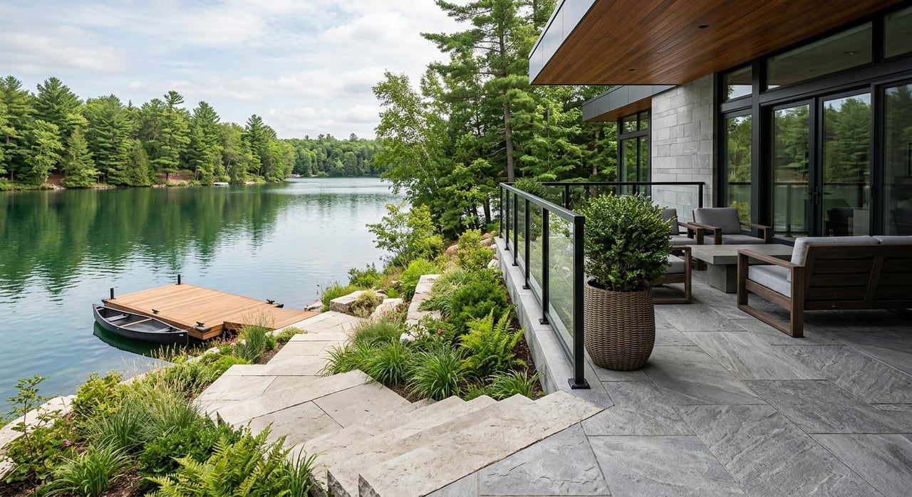
- Water access and usability. The ability to launch a boat, use a dock, and reach navigable water drives demand. Homes with reliable access across a wider range of levels usually command stronger interest.
- Views and aesthetics. A high, sparkling lake can elevate the view. During low water, exposed rocks or mud can reduce visual appeal. Buyers react to what they see at showing time and in recent listing photos.
- Waterfront vs. water-adjacent. In very low periods, some parcels can lose water contact. That shifts how a property should be positioned and what comps are relevant. Clear, accurate language helps set expectations.
Function and maintenance
- Docks and lifts. Fixed docks may become unusable outside their design range. Adjustable or seasonal floating systems expand usability but carry higher cost. Ask for permits and recent condition reports.
- Shoreline erosion. Wave action and fluctuating water levels can cause erosion. Owners often use riprap, retaining walls, or native plantings, usually with permits. Proactive stabilization can protect land and structures.
- Septic and wells. Very high water or flooding can affect septic systems or drainfields. Low water can influence groundwater conditions for shallow wells. Regular inspections reduce surprises.
- Access and ramps. Low water can close some ramps. High water can flood low-lying roads or driveways. The reliability of access is a practical value driver.
Legal and insurance considerations
- Flowage and inundation easements. Public authorities may hold easements that allow water to cover parts of private land at certain elevations. Know where those lines are on your survey and how they affect use.
- Permitting for shoreline work. Docks, boathouses, seawalls, and major vegetation changes typically require permits from LCRA and local jurisdictions. Unpermitted work can be subject to fines or removal.
- Flood maps and insurance. FEMA Flood Insurance Rate Maps guide lender requirements and premiums. Being above a mapped floodplain reduces mandatory insurance in many cases, but access roads or utilities can still face risk during high water.
- Local rules. County and municipal setbacks, septic zoning, and building codes interact with lake-level risk. Confirm requirements before you plan any improvement.
Appraisal and market perception
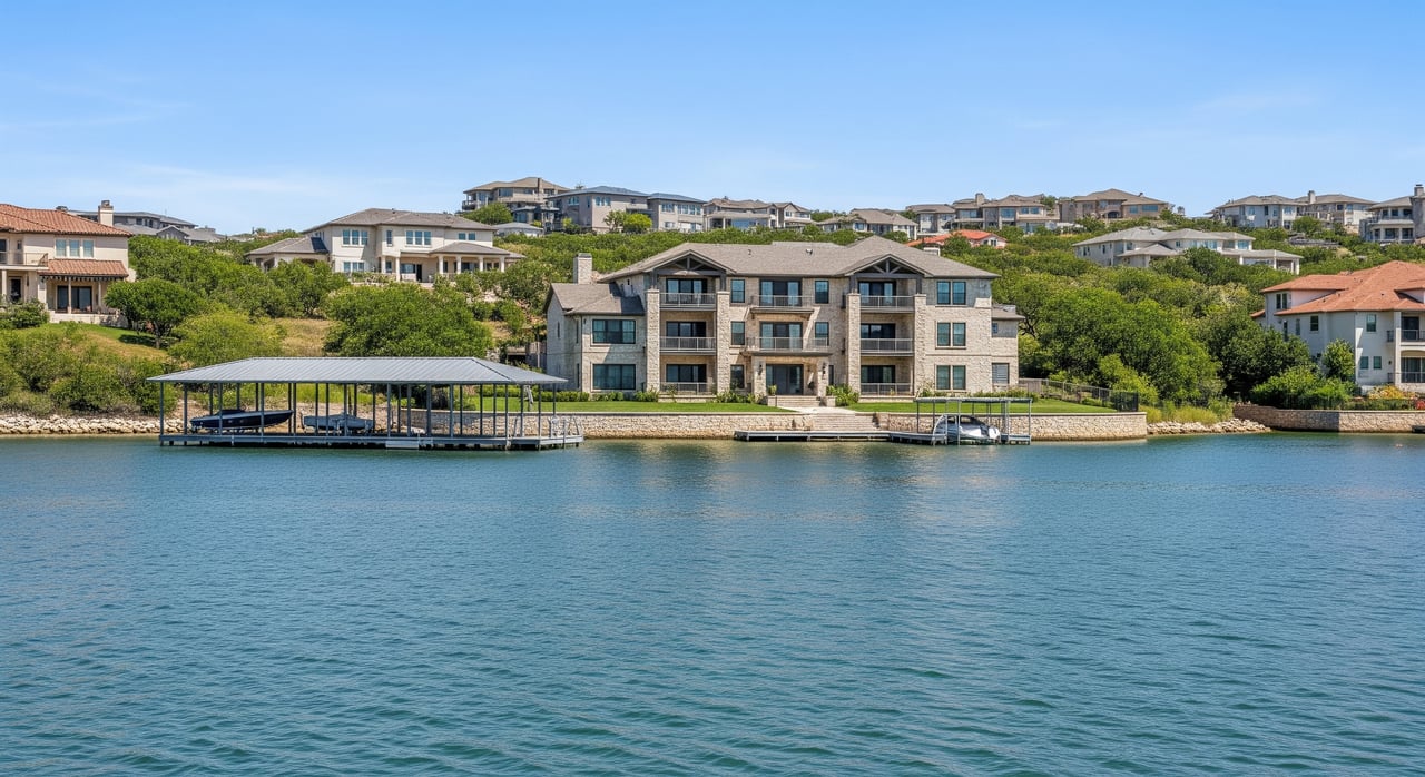
- Waterfront premiums vary. Waterfront homes generally trade at a premium over similar non-waterfront properties, but the premium depends on access, view quality, and risk factors. Appraisers look for recent comps with similar water conditions.
- Time-sensitive comps. Rapid changes in elevation can make last month’s sale less comparable if water access was different at that time. Context matters.
- Condition and mitigations. Adjustable docks, permitted shoreline stabilization, and high-elevation building pads help preserve value and give appraisers stronger support.
Buyer due diligence checklist
Use this list before you write an offer and during your option period:
- Check current lake elevation and the historical range using official sources.
- Verify dock and mooring status with permits, recent inspections, and photos that show functionality at different levels.
- Order a title commitment and boundary survey. Look for any LCRA flowage or inundation easements and public access easements.
- Request copies of shoreline permits, riprap or retaining wall approvals, and any correspondence with LCRA.
- Review FEMA flood maps and consider an elevation certificate if the home or access sits near a mapped flood zone.
- Hire certified septic and well inspectors. Confirm systems are suited for lake-level variability.
- Confirm access roads, driveways, and utilities are unlikely to be routinely affected by high water events.
- Ask your agent and appraiser to use comps with similar water access and to note the lake elevation at the time of each sale.
- Get quotes for homeowners and flood insurance from agents experienced with lakeshore properties.
Seller strategy in any level
If you are preparing to list on Lake Travis, lead with clarity and documentation:
- Disclose and document. Gather dock permits, shoreline permits, surveys, and any LCRA notices. Provide photos at different lake levels.
- Consider targeted upgrades. An adjustable dock, permitted erosion control, or improved driveway elevations can reduce buyer concerns. Prioritize items that add usability and confidence.
- Position the home accurately. Use clear terms like “lakefront with seasonal dock,” “deep-water,” or “water view.” Include recent, level-accurate photography.
- Price with context. Work with an agent who understands Lake Travis to select comps that reflect similar conditions. Adjust for access and improvements that mitigate variability.
- Time your launch. If possible, list when the lake shows well. Still provide the historical context buyers need to make an informed decision.
Smart contingencies to include
Buyers can protect their interests with clear agreement terms:
- Satisfactory verification of dock and shoreline permits and functionality
- Right to review LCRA correspondence and a historical lake-level chart
- Septic and well clearance or repair contingency
- Survey confirmation of boundaries and easements
Mitigation upgrades that help value
Common options
- Adjustable or floating docks. Improve usability across a wider elevation range. They cost more but tend to be favored by buyers.
- Riprap, revetment, or retaining walls. Help manage erosion. Expect permitting and ongoing maintenance.
- Vegetative stabilization. Native plantings provide lower-cost erosion control. They require time to establish.
- Elevated siting. New builds can place primary living areas above high-water elevations to reduce flood risk.
- Improved access. Raising driveways or adding alternative paths to deeper water can improve daily use.
Key tradeoffs
- Permits and compliance. Many shoreline fixes require LCRA and local permits. Unpermitted work can harm value.
- Aesthetics vs. function. Hard edges may solve erosion but do not suit every buyer. Naturalized shorelines can appeal to those who value ecological design.
- Cost vs. return. Upgrades that expand usability and reduce risk, like adjustable docks and permitted stabilization, often improve marketability more than their raw cost suggests.
Pricing and timing in a changing lake
You can optimize outcomes when you align pricing, presentation, and timing with current conditions. Recent photos, transparent disclosures, and comps tied to the lake elevation at the time of sale build credibility. Features that increase reliability of access and reduce maintenance risk can support a stronger price even when the lake is low.
If you are buying, remember that a property shown during low water might gain utility as levels recover. If you are selling, demonstrate how your home performs across a range of elevations and highlight permitted improvements that protect the shoreline and systems.
Where to find trusted information
- LCRA for real-time and historical lake elevations, operational notices, and shoreline permitting requirements.
- FEMA Flood Map Service Center for flood zone designations and insurance guidance.
- County permitting offices around Lake Travis for shoreline, septic, and building permits.
- County appraisal districts for parcel records and sales history.
- Local lenders, insurance agents, marine contractors, and appraisers with Lake Travis experience for practical costs and risk insights.
Work with a Lake Travis expert
Lake Travis is a premium lifestyle market, and level changes reward owners and buyers who plan ahead. With seasoned guidance, you can price, position, and negotiate to your advantage in any cycle. If you want a private, boutique experience and micro-market insight across the west Austin and Hill Country waterfront, connect with Jana Birdwell to discuss your goals.
FAQs
Who manages Lake Travis water levels?
- The Lower Colorado River Authority operates Mansfield Dam and manages releases and storage to balance water supply, flood control, hydropower, and recreation.
Do low levels change a home’s waterfront status?
- Yes. In very low periods, some parcels lose direct water contact, which affects listing language, comps, and buyer expectations.
Is flood insurance required on Lake Travis?
- It depends on FEMA flood zone designation and lender policy. Being above the mapped floodplain can reduce requirements but does not remove all risk.
Can you build a dock or seawall on Lake Travis?
- Often yes, but docks, boathouses, seawalls, and major shoreline changes typically require permits from LCRA and local jurisdictions.
How do appraisers handle level swings in valuations?
- Appraisers use recent comparable sales with similar access and note lake conditions at the time of each sale. Mitigations like adjustable docks and permitted stabilization support value.